🌦17JUN2023 - 1245 PDT🌦
Hello everyone! After a warm late Spring and beginning of meteorological Summer (June 1st), the Pacific Northwest is about to go into a winter-like pattern for a few days. The weather must have heard the pluviophiles' pleases...
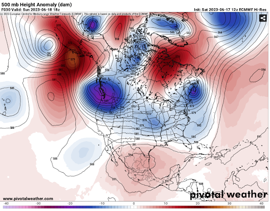
This pattern won't bring a ton of rain but it will be damp, cool/cold, and cloudy for many. The mountains will likely get some snow too! Let's dive into things by first looking at the upper-level (high up in the atmosphere) trough (blues and purples) and ridge (reds and oranges) positions. As you can see below, the PNW is going to be under the influence of a deep, cold trough of low pressure. This will bring mountain snow and lowland rain chances through Tuesday/Wednesday of next week. Gusty winds will also be apparent over the mountains of Washington and Oregon so bring some extra layering when heading into the backcountry!
Trough and Ridge positions
Now let's take a closer look at western Washington where more localized weather features will be bringing rain and gusty winds to some.
First off, this cold trough over the region will create strong onshore flow (from the west) over much of western Washington. Due to the Olympic Mountains, the winds get split into two different sections. One goes to the north of the mtns down the Strait of Juan de Fuca. The other goes south of the mtns through the Chehalis Gap. As seen in the first image below, these two winds meet up creating the Puget Sound Convergence Zone. This convergence of winds will result in localized areas of higher rain totals from southern Whidbey Island down through the Seattle Metro. The Strait of Juan De Fuca westerly winds can also get quite strong which will happen this afternoon/evening. In the second image below, you can see that a ***Gale Warning*** has been issued for the Strait because of wind gusts up to 40-45mph are expected. This will pick up again tomorrow afternoon. This is why Whidbey Island has been deemed "Windy Whidbey".🌬🍃
Simulated Radar Imagery from UW's WRF-GFS Model
NWS Seattle's Warnings/Advisories
When it comes to rain total for the PNW, generally most areas will get a good bit of rain unless you live in the Columbia Basin (sorry). The Oregon cascades look to get quite a bit with 1-2 inches expected in some areas. This will all be very beneficial to stalling wildfire season even if it isn't a ton. Anything helps this time of the year!☔
UW's WRF-GFS 84hr Precipitation Totals
Looking ahead, a weak ridge of high pressure (seen below) will build over the region creating warmer and drier weather from the middle to late next week. Though some showers/thunderstorms for Montana and Idaho will be possible later in the week. June will be back to its normal self!🌞
Trough and Ridge positions for later next week.
I hope everyone enjoyed this blog! Sorry for such a long wait between the last blog and this one. I had school/finals I had to focus on. Will be back with another forecast when able!
God bless and take care!


.png)

Comments
Post a Comment