Warm and Nice with Alpine Thunderstorms for the PNW(and Some Upper-level Smoke)
Hello there everyone to my first-ever blog! I am excited to try to make at least one blog each week where I will go a bit in-depth about what weather the PNW looks to be expecting. *Expect some humor also mixed in*

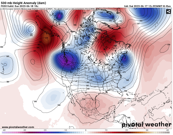
Let's start out by going over what is happening right now. Below you will see the simulated high-pressure ridge (reds and oranges) and low-pressure trough (blues and purples) positions from the GFS model. This gives us a good overview of what conditions will probably be like in parts of North America. Out west, we have a large ridge causing above-average warmth for this time of the year and little to no precipitation. While out east a trough is causing cooler and more unsettled weather. The placement of this ridge over the west is also causing the airflow over the PNW to be favorable for smoke from the Canadian wildfires to enter the region (for the time being). This was very evident during the sunrise this morning which Randy Small from the Whatcom County Weather Page on Facebook captured beautifully (see below)…

 |
Whatcom County Weather:⬇
https://www.facebook.com/WhatcomCountyWeather |
What can the PNW expect for the rest of the week into the weekend?
For the remainder of this week, the PNW will mainly be clear of most storminess, but places near the Cascades and eastward will have daily chances of convection and in turn thunderstorms. There is a chance some of these storms could get close to the lowlands of western Washington on Thursday, May 18th, but storms look to mostly stay east. The Storm Prediction Center has highlighted the thunderstorm chances over the next few days (see below)…
 |
| SPC t-storm outlooks for the next 3 days. Day one is today and day three is Friday. |
Now let's talk smoke. As seen on the GOES-West satellite imagery below, a band of wildfire smoke from Canada can be seen draped across Washington, Idaho, and Montana. This is creating hazy and lazy skies today but for the most part not affecting air quality on the ground. This is great news, at least for my lungs. The image below the satellite imagery is the simulated vertically integrated smoke which in layman's terms is just how much smoke there is in the atmosphere. Look at that! The model shows by Friday that the smoke should be out of western Washington and Oregon lungs and skies. Sadly eastern Washington, Idaho, and Montana will hang around with the smoke for longer. So anyone west of the Cascade Crest can breathe easier (literally) now that you know most of this smoke won't last around for too long...
 |
| Wildfire smoke is that mass of light brown/gray near the top of the image |
 |
| Red and purples are thicker smoke plumes. Wow! That smoke reaches basically from coast to coast! |
With the stout ridge dominating the west coast warm temperatures (70 and 80-degree temperatures) will be common Cascades west and very warm to downright hot temperatures will be common in eastern portions. Below is the predicted temperatures for Saturday the 20th by the ECMWF model (short and less complicated name: the EURO). Look at that! Those white colors indicated the model is predicting 90s and possibly even low 100-degree temperature readings for the Columbia Basin in eastern Washington! Make sure to protect animals and kids during the heat by not leaving them in closed vehicles and making sure they are drinking plenty of water. Also, the area waters are still very cold and rivers are running high and swift so always make sure to wear life jackets when recreating in the water! Temperatures across the region look to cool by Sunday, May 21st as strong onshore flow (from the ocean) brings lots of marine air in...

And that concludes my first blog! Thanks for reading and please enjoy the rest of your week and keep those sunglasses nearby with all that abundant sun around! Next blog later this weekend or early next week. Take care and God bless.
.png)
Very nice!
ReplyDeleteGreat blog, Jonathan! Looking forward to following along!
ReplyDeleteGreat information. Thank you!
ReplyDelete